California's Best Camping
For complete information about all the best camping in the area, including Donner Lake and around Lake Tahoe, visit our sister website, California's Best Camping
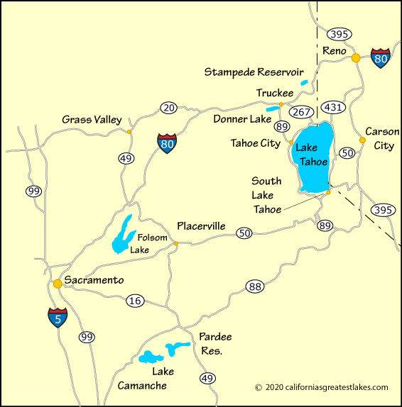
From almost anywhere, the fastest way to the north shore of Lake Tahoe is to come in via Interstate 80 and then travel south either to Tahoe City or Kings Beach and Incline Village. Anyone coming from Reno would take Highway 431, while from Carson City, Highways 50 and 28 make the fastest route.
Coming from South Lake Tahoe, it is faster to travel around the Nevada side of the lake if headed to Incline Village or Kings Beach. For Tahoe City it is faster to drive up the California side of the lake. Summer traffic can make Highway 89 past Emerald Bay very slow.
For complete information about all the best camping in the area, including Donner Lake and around Lake Tahoe, visit our sister website, California's Best Camping
| Miles | Hours | Mins. | |
|---|---|---|---|
| Bakersfield | 388 | 6 | 13 |
| Fresno, CA | 286 | 4 | 41 |
| Las Vegas, NV | 489 | 8 | 11 |
| Los Angeles | 499 | 7 | 53 |
| Reno, NV | 43 | 0 | 53 |
| Redding | 271 | 4 | 22 |
| Sacramento | 117 | 2 | 00 |
| San Francisco | 243 | 4 | 07 |
| San Jose | 229 | 3 | 49 |
| South Lake Tahoe | 36 | 1 | 11 |
| Stockton | 164 | 2 | 42 |
| Truckee | 15 | 0 | 25 |